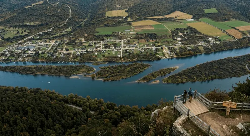
The high ridges surrounding the Allegheny River have always offered spectacular views, but for nearly a century, one destination has stood as the definitive vantage point. Situated hundreds of feet above a dramatic horseshoe bend in the river, the Tidioute Overlook is more than just a scenic stop; it is a historical landmark that tells the story of the river, the railroad, and the resilience of a small Pennsylvania town.
For travelers navigating Route 62 through Warren County, the overlook is an essential pilgrimage. It offers a panoramic perspective that connects the industrial heritage of the valley floor with the vast, unbroken wilderness of the Allegheny National Forest on the opposite shore.
1. The Geometry of the Horseshoe Bend
The Tidioute Overlook doesn't just offer a view; it reveals the fundamental geometry of the Middle Allegheny River. Far below, the water carves a perfect, symmetrical horseshoe curve around a massive forested peninsula known as "Thompson’s Island." This dramatic bend slows the river down, creating deep pools and unique structural habitat that make it a legend among smallmouth bass and walleye anglers.
2. A Rustic Legacy: The Hand of the CCC
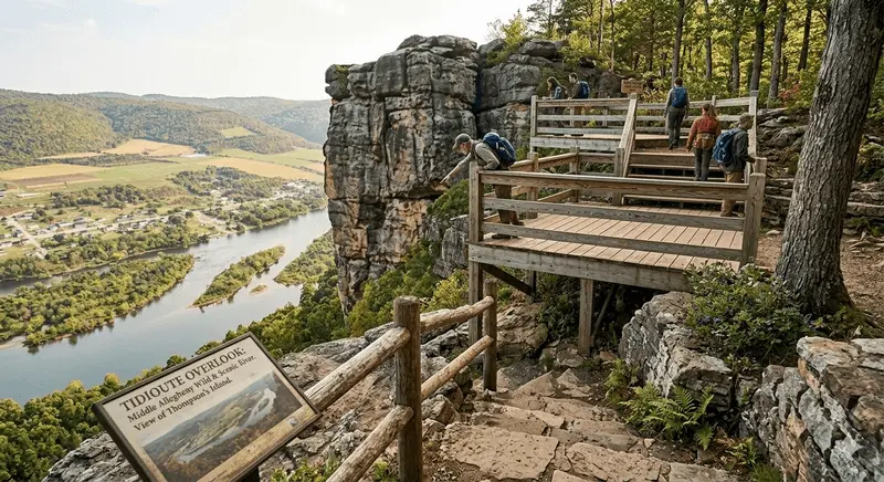
The platform itself is a masterpiece of "Rustic Architecture," the signature design philosophy of the Civilian Conservation Corps (CCC). Built in the late 1930s by the young men of Camp Beaver (the very same crew that sourced the local sandstone for structures like image_32.png), the Tidioute Overlook was designed to look like a natural extension of the cliff.
The original viewing deck featured massive, hand-hewn hemlock timbers and native riverstone pillars, balancing the view with structures that "grew out of the ground." While modern safety upgrades have added steel and composite materials, the CCC’s foundation—the massive retaining walls anchored directly into the bedrock—still holds the mountain together.
3. "Watching the Rails": Tidioute’s Industrial Heart
From this height, the layout of the town of Tidioute (the Seneca word for "logs in the water") is perfectly clear. You can trace the historic route of the Pennsylvania Railroad, which once ran along the western bank, fueling the lumber and oil booms.
-
The Log Drives: In the 19th century, this bend was a dangerous choke point for massive log rafts floating downriver to Pittsburgh. Tidioute was a rough-and-tumble town built on the muscles of river drivers.
-
The Oil Derricks: Following the 1859 Titusville strike, the Tidioute hillsides were thick with wooden derricks. From the overlook, you are looking at the footprint of the world's first global energy boom.
4. Preserving the View for the Next Century
Today, the Tidioute Overlook is a key component of the Allegheny Wild and Scenic River corridor. It is managed not just for its view, but as an interpreter of the landscape. Recent improvements have added interpretive signage detailing the history of the 19th-century raftsmen and the local ecology. The site is a reminder that while the industry has moved on, the fundamental beauty of the river curve and the dedication to public access—first established by the CCC 90 years ago—remains unchanged.