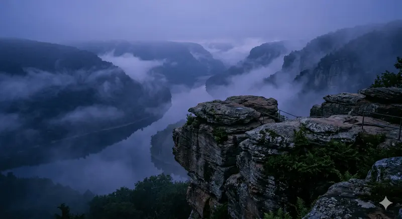
To look out from Jakes Rocks, high above the looping expanse of the Allegheny Reservoir, is to witness the landscape of the "Pennsylvania Wilds" defined by a defining geological characteristic: it is unglaciated.
This high, rugged plateau was never scrubbed raw by the towering ice sheets that defined much of North America during the last Ice Age. Instead, it is an ancient landscape, millions of years older than the smooth, rolling hills found just miles to the north. Jakes Rocks provides a dramatic and primary window into this "deep time" history of the Allegheny Highlands—a narrative of massive ancient rivers, catastrophic deposition, and hundreds of millions of years of uninterrupted erosion.
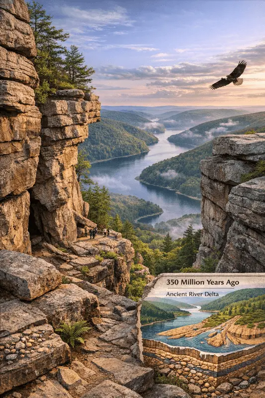
The Foundations: The Devonian Delta (350 Million Years Ago)
The story of Jakes Rocks begins in the Paleozoic Era, during the Devonian Period. The unglaciated plateau was not a highland at this time; it was the eastern edge of a vast, shallow epicontinental sea. To the east, the ancestral Appalachian Mountains (the Acadian orogeny) were rising.
As these massive mountains weathered, catastrophic rivers carried immense volumes of sediment—sand, gravel, and quartz pebbles—westward. These rivers deposited their loads in a sprawling, coastal delta system. This is the material that forms the massive, cross-bedded sandstone and conglomerate outcrops we see at Jakes Rocks. The distinct layers visible within the rock formations are the preserved fingerprints of those ancient river channels, recording the pulse and flow of a 350-million-year-old environment.
The Great Escarpment: The Making of "Rock Cities"
What makes Jakes Rocks geologically significant is that these Paleozoic layers were later uplifted and then exposed by endless millennia of erosion. The unglaciated plateau is a testament to natural forces working on a monumental time scale without the interruption of glacial scouring.
Over time, this erosion targeting softer shale and siltstone below, undermining the massive sandstone layers of Jakes Rocks. This led to a dramatic phenomenon: massive, whole sections of the caprock separated from the main escarpment along vertical joints (fissures), creating deep, linear alleys, passages, and towering individual blocks. These are the "rock cities" that define Jakes Rocks. While common across the unglaciated plateau, the "city" at Jakes Rocks is unique because it is situated directly on the rim, showcasing the dramatic scale of the separation from the modern reservoir hundreds of feet below.
The V-Shaped Valleys and the Atmosphere of the Wilds
The unglaciated status of the Allegheny National Forest also defines its overall topography. Because glaciers never filled the valleys and rounded the slopes, the landscape is defined by its repeating, sharp, V-shaped valleys (gorges).
The original Allegheny River and its tributaries, including the now-submerged Tionesta Creek, spent hundreds of millions of years cutting vertically into the plateau. The result is a landscape of profound confinement—a series of deep, narrow sound chambers that naturally trap fog and sound. This environmental reality is the foundation for the region’s distinct visual and cultural identity, giving birth to the pervasive blue-purple fog, the "Death Shout," the "Witch Killer" folklore, and the submerged, haunting history of the "Lake of Perfidy."
Jakes Rocks is not merely a scenic overlook; it is a primary geological classroom. It is a vertical section through time, connecting the modern viewer to the very foundations of the Paleozoic Era and explaining why this unglaciated landscape holds its moisture, its echoes, and its ancient secrets so potently.