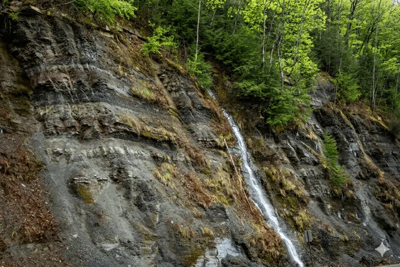
For many travelers, the massive rock face along Route 59 just past the Kinzua Dam is merely a striking landmark—a sheer cliff face resulting from the massive construction project that built the dam. However, to geologists and keen observers, this extensive "road cut" is something much more: it is a window into a world that existed hundreds of millions of years ago.
This vast vertical exposure, where the hillside was blasted away to make way for the road, provides unparalleled access to the strata (rock layers) that make up the Kinzua region. To understand what this rock face is telling us, we must first learn how to read its specific language.
A Layered Chronology
The Route 59 rock face (seen in the accompanying image) is a chronological map. The layers at the bottom are the oldest, and each successive band on top is slightly younger. This entire sequence belongs to the Upper Devonian period, dating back roughly 360 to 370 million years.
During that time, this area was not a forested hillside; it was the shoreline of a vast, shallow inland sea. To the east, the newly formed Acadian Mountains were eroding rapidly, and massive river systems were carrying vast amounts of sediment (mud, silt, sand) westward, depositing it in a monumental delta complex known to geologists as the Catskill Delta.
This single roadside exposure captures the complex interplay of that delta's deposition.
The Specific Layers: Shale, Silt, and Red Beds
When we look closely at this outcrop, we can clearly identify the three main types of rock that dominate the region's geology:
1. Grey and Olive Shales
The most abundant, crumbly layers are shales and siltstones. These represent fine-grained mud and silt deposited in relatively low-energy environments, such as deep-water delta slopes or quiet marine basins where the finer particles could settle. These layers are part of the Canadaway or Conneaut Group.
2. The Famous "Red Beds"
Interspersed within the grey shale, you will spot distinct bands of reddish-brown or purplish mudstones. These are the hallmark of the non-marine or marginal-marine part of the Devonian. Geologists interpret these "red beds" as ancient paleosols (fossil soils) that formed on the dry parts of the delta plain. Their reddish color comes from the oxidation (rusting) of iron minerals when exposed to the air. Finding red beds means this specific spot was, for a time, a muddy floodplain or estuary rather than the sea floor.
3. Protruding Sandstone Benches
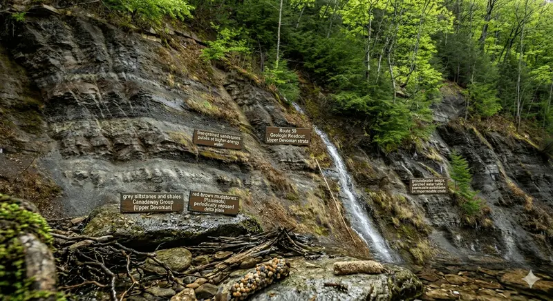
Finally, there are harder, more protruding horizontal layers that don't weather away as quickly as the shale. These are fine-grained sandstones, which represent pulses of higher-energy water—perhaps from ancient storms or shifting river channels on the delta plain that carried larger sand particles into the basin.
The Weeping Rock: Water and Permeability
The presence of the prominent waterfall and smaller wet "seeps" (often called "weeping" outcrops) visible on the rock face is another powerful geological clue. This phenomenon is a direct result of the specific architecture of these rock layers.
Groundwater moves easily through the porous sandstone layers. When this water encounters an underlying, impermeable layer of dense shale (like the grey shale seen throughout the outcrop), it can no longer move downward. Instead, the water is forced to move horizontally until it finds an exit—which, in this case, is the sheer vertical face created by the blasting for Route 59. This intersection of permeable sandstone and impermeable shale forms a natural perched water table.
A Legacy of "Black Gold"
Understanding the composition and orientation of these vertical layers is not just an exercise in abstract geology; it is the physical foundation of the region's economic history.
This specific vertical stacking of rock types—dense, impermeable shales sealing off more porous sandstones—is what created the perfect geological trap for petroleum. When organic material trapped in deep shales broke down over millions of years and migrated upward as oil and gas, it was caught by the "cap rock" shales, accumulating in the sandstone layers below. This specific pattern is why the Allegheny Plateau became the birthplace of the modern oil industry.
Preserving a Record
The blasting that created Route 59 was a massive disruption to the natural landscape, but it also accidentally preserved a pristine geological record that would otherwise be hidden deep within the mountain. This roadside face is a world-class exposure, offering a textbook example of the complex transition between ancient marine and terrestrial environments. It serves as a powerful reminder that the landscapes we see today are merely the latest chapter in a deep-time epic written in stone.